Autumn in Debabarrena: discover our hiking trails
Sep 24, 2019
As we bid summer goodbye in Debabarrena, autumn begins, bringing moderate temperatures and leaves changing colour. Now it is the perfect time to discover our mountains and valleys through our many hiking trails. Don’t miss our recommendations.
Summer is over, but the weather is still mild in Debabarrena . If you come to our region in autumn, you will find many options to enjoy nature. When temperatures lower, and the trees begin to change the color of their leaves, it is the perfect time to discover the hiking trails of Debabarrena.
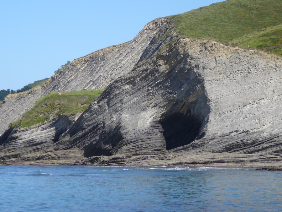
The first path we suggest is probably known to many of you. This is the GR-121, which bears the nickname of Talaia, and in the section between Deba and Zumaia it is known as the Flysch Trail. In slightly under 23 kilometers that run along the coast of Debabarrena, you can walk between spectacular cliffs, with the sea always on one side. The trail offers unbeatable views of the flysch, especially from the viewpoints of Elorriaga and Mendatagaina. The road also leads to the historic center of Mutriku, a jewel of steep streets that hides more than one treasure, such as the Arrietakua Palace. In addition, this trail is part of the Camino de Santiago, the variant called Camino de la Costa, so it is common to find pilgrims at any time of the year.

Further inland from Deba we find the town of Mendaro, located in the valley of the Kilimon River, tributary of the Deba River, after which our region is named. In this valley we propose a trail of less than 7 kilometers, with a gentle inclination, a perfect route for families. The road (PR-Gi 42) goes into the valley of the Kilimon River, and besides allowing you to enjoy landscapes full of vegetation, it offers the possibility of exploring heritage elements such as the Lasalde Tower House.

Following the valley of the Deba upstream, we arrive at Elgoibar, and on the edge of this town with Soraluze, we find one of the best viewpoints of all Euskadi, on the summit of Mount Karakate. And from here departs another of our best known trails: the Dolmen Trail, or PR-Gi 94. This route, 11 kilometers long, connects the top of Karakate with that of Agirreburu, and along the range offers stunning views towards the sea and the mountains of Euskadi. But undoubtedly the most remarkable thing about this route is that it runs between prehistoric monuments: the Elosua-Placencia megalithic station is on the route, with a total of 19 elements: dolmens, burial mounds, and a menhir. It is worth entering this path to learn more about the prehistory of Debabarrena.

Our next proposal is not far from Elgoibar. Facing Mount Karakate, on the other side of the Ego River, is the Sanctuary of Arrate, home of a virgin dear to both eibartarras and many people in Debabarrena. There is also a playground and two restaurants near the sanctuary, making it an ideal starting point for hiking in the mountains that surround it. And here begins the path PR-Gi 108, which goes up to the tops of two renowned mountains of Eibar: Kalamua and Akondia. The trail is a little less than 8 kilometers long, and is of medium difficulty. It also has a rest area with a fountain, where you can stop to regain your strength before starting the descent.

The last proposal of this article crosses the border to Bizkaia, since Debabarrena is made up of 6 municipalities in Gipuzkoa, and 2 in Bizkaia. It is between the latter two, Ermua and Mallabia, where this path runs, the PR-Bi 70. It is a circular route of just over 6 kilometers, linking the two towns, and we recommend starting it in Ermua, going towards the neighborhood of Goitondo next to the road. On the way you will cross native forests and several farms, as well as the recreational area of Errekalde, where if temperatures require it, you can cool off with a bath.

As you can see, Debabarrena offers a wide range of options to enjoy nature. You can explore our network of hiking trails on our website, or on our Wikiloc profile, where you can even download the GPS tracks and enjoy the routes without worries. Do not miss it!