Urko

The ridge formed by the hills Urko and Akondia are part of a green mountainous barrier separating Gipuzkoa y Bizkaia and dividing the Deba basin from those of the rivers Lea and Artibai.
The highest point (Urko) ascends to 791m. Despite their relatively low altitude, the peaks offer unique panoramic views of the area and the mountains further inland. The strategic position of the area, with the pass of Usartza connecting the basin of the River Deba and those of Lea-Artibai, has marked its history, one of belligerence and conflict, but also of commerce as a trade route between the coast and the interior.

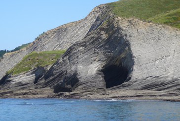
View of Urko, in Eibar (Gipuzkoa).
As far back as the 14th century, Lope Garcia de Salazar , in his work Bienandanzas e Fortunas , made reference to battles fought between feuding families on the passes near the chapel of San Pedro of Akondia. During the Civil War too (1936), this position was a strategic point in the defence of Eibar against the advance of Francos troops. Even today, the trenches which made up the defensive belt can still be seen on the hill of Akondia.
But history is not only wars. In the Middle Ages these paths were part of the coastal route of the Santiago Way, leading from Arnoate, across the pass of Urkaregi (San Miguel) to Arrate. From here, after visiting the chapel of San Pedro of Akondia (possibly one of the oldest in these parts), the route followed the old road past the Image of San Ildefonso and the chapel of San Roman, before entering Bizkaia through the village of Barinaga.
How to get there:
From Eibar: take the road to Arrate. You have the choice of starting from Ixua (access to Urko, Akondia and Kalamua), or from the Sanctuary of Arrate.